

After Decades of Neglect, the L.A. River Is Making A Comeback
After Decades of Neglect, the L.A. River Is Making A Comeback
Long derided as a 51-mile concrete ditch, efforts are being made to turn it into a recreational destination; developers are not far behind.


The seemingly endless sprawl that is Los Angeles really does, in fact, end. I was in Canoga Park, in the San Fernando Valley, driving west on Roscoe Boulevard through a mind-numbing landscape of sameness. Then I crossed Valley Circle Boulevard and the city abruptly stopped. On one of side of the street were houses; on the other side, there was nothing. A sign indicated the entrance to Roscoe-Valley Circle Park. Beyond it, a footpath led up a gentle incline toward the brow of brown hills and, towering behind them, a range of mountains.
I was looking for a river and I found it. Except it wasn't a river. It was a dry gulch, sheltered by a thicket of dusty trees. My Thomas street guide said this was Dayton Creek. On the map, it was a thin blue line squiggling east until it connected to a thicker blue line that bore the legend Los Angeles River. In person, it was a dirt ravine, just an aspiring stream waiting patiently for rain.
You can sign up at secondacts.bulletin.com/subscribe to get free posts delivered to your inbox each week and read past articles. You also follow me on Facebook, Instagram and Twitter.
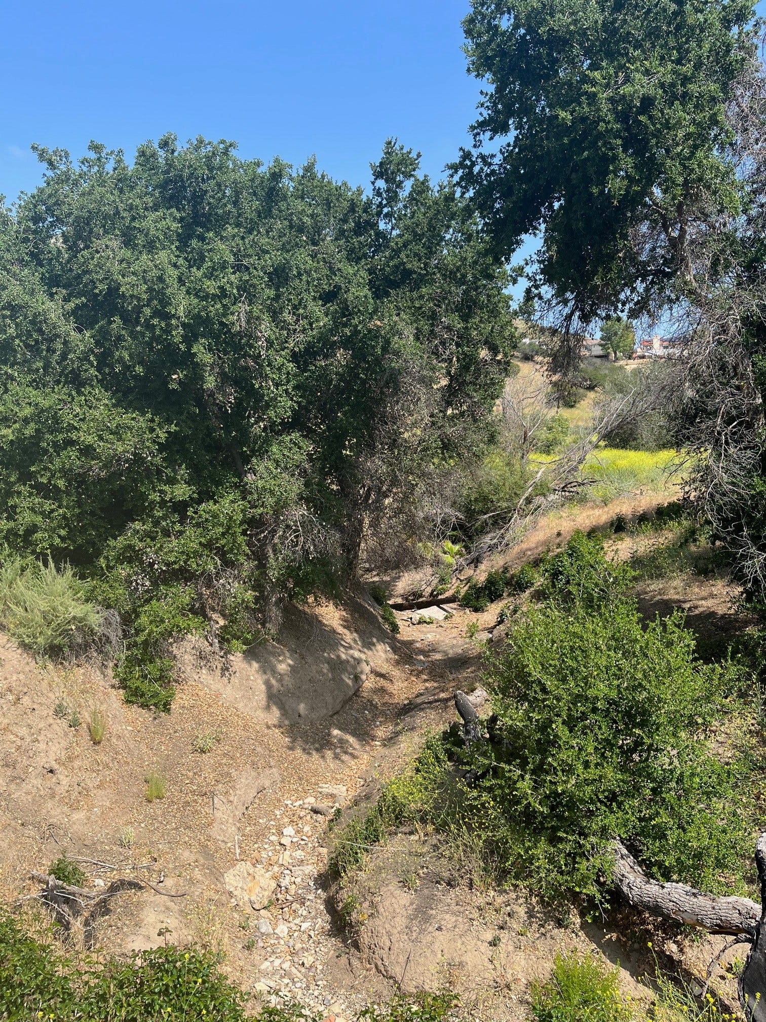
Where the L.A. River begins, when there's rain. Photo credit: Ron Claiborne
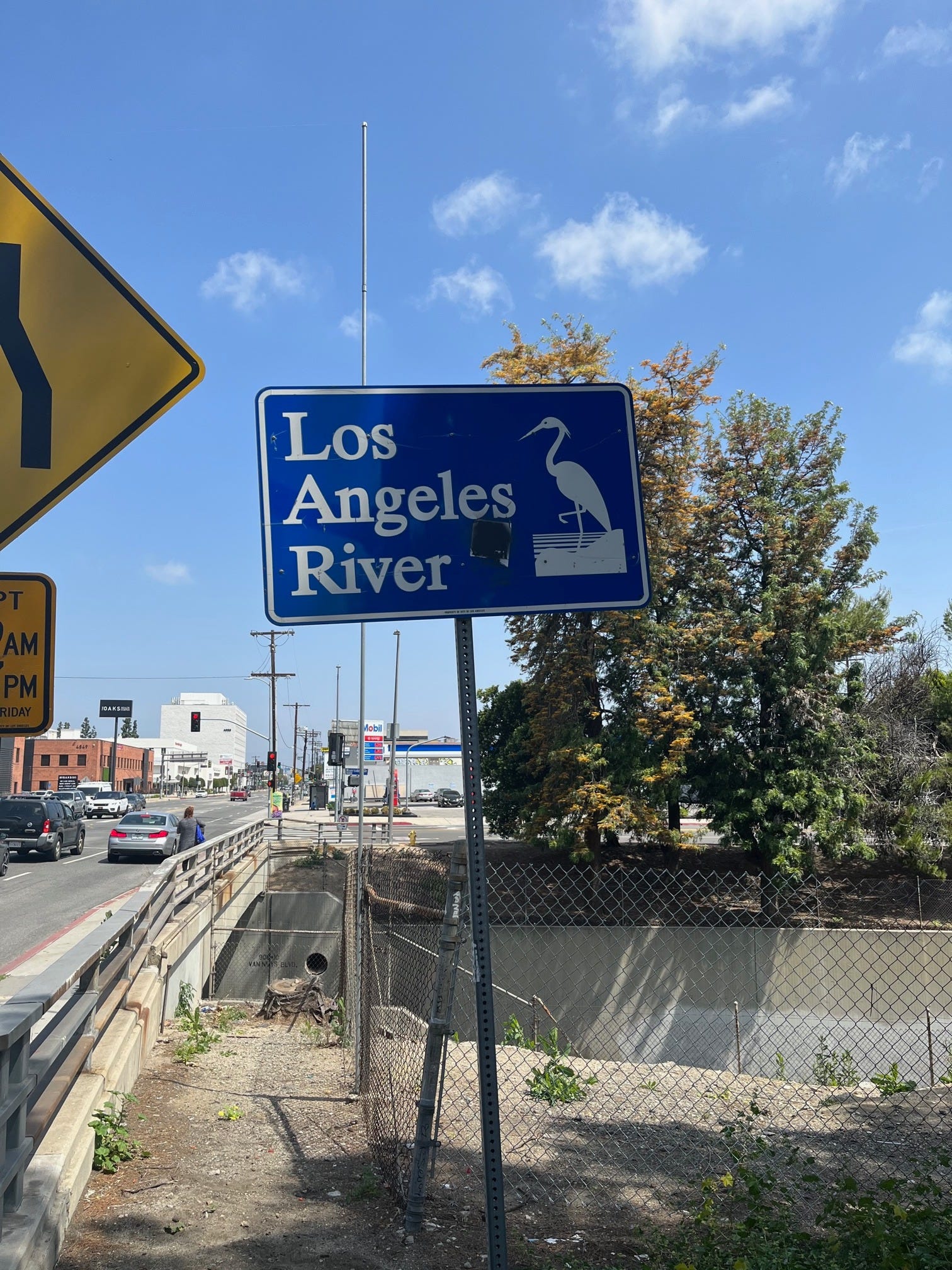
The Los Angeles River is 51 miles long, originating deep in the Valley and spilling out into the Pacific Ocean at Long Beach. When it rains, it's fed by a network of creeks, smaller rivers and tributaries flowing from the San Gabriel and Santa Susana mountains. Most of the year it contains only the spotty discharge from waste water treatment. But when it rains hard, it quickly becomes a violent torrent that can and does kill.
"It was a mere trickle most of the year," wrote Michael Connolly in The Narrows, one of the crime novels in the terrific Harry Bosch series. "A municipal joke even. But a rainstorm would awaken the snake and give it power. It became the city's gutter, millions and millions of gallons banging against its thick stone walls, tons of water raging to get out, moving with terrible force and momentum."

Photo credit: Getty Images
If you don't know there's an L.A. River, that's not unusual. A lot of people who live in L.A. don't think about it, if they even know about it. If you're not from L.A., chances are you never noticed it. I grew up in Los Angeles and really never gave it a passing thought. It wasn't a river. It was a concrete ditch.
River overpass in Sherman Oaks. Photo credit: Ron Claiborne
"When I was growing up, the river wasn't something that you went to visit," Yolanda Hernandez, who grew up less than a mile from the river in the Glassell Park neighborhood recalled in a 2018 Sierra Club website article. "The only time you heard anything about it was when kids were skating there or something, or when some kid drowned. It wasn't something you would go see. It was more like, 'Stay away.'"

L.A. River, east of downtown. Photo credit: Ron Claiborne
That's changing. City officials are embracing the river for its commercial and recreational potential. Private developers are putting up residential housing alongside it while casting covetous eyes to its miles of undeveloped or, in their eyes, underdeveloped stretches. Miles of bike paths have been built. At times, you can kayak or fish in it. The forces of progress ruined the river. Now they're seeking to reclaim it.
"It was something we sought to use, to control, and we turned our backs to it," Los Angeles Mayor Eric Garcetti said, according to the website, LA Curbed. "Now we seek to co-exist with it and to live side by side with it, and to turn our faces to it again."
L.A. Times columnist Patt Morrison wrote last May, "In Hollywood fashion, after years as a nonentity, the L.A. River is having a career revival, starring as itself in an urgent real-time, real-life comeback docudrama."

Near Elysian Park. Photo credit: Ron Claiborne
Two hundred years ago, long before there was a Los Angeles, the river was the lifeblood of the native people who lived in that area.
"There would not be a Los Angeles without the L.A. River," says Morrison, author of the book Rio L.A., Tales from the Los Angeles River. "We always think of the coast, but it was the river that brought settlements here. It's the river alongside which Native Americans built their communities, and it's the river that the Spanish gravitated to when they came here in the 18th century."
The Tongva native people lived beside the river for hundreds of years. The area they inhabited was forested and teemed with wildlife, including bears. Fish were abundant.
"Their principle village, Yaangva, flourished on the banks of the Los Angeles River, providing resources like fish, nutrient-rich soil and fresh water before it empties into the Pacific Ocean," according to an article by Taylor Haynes in Culture Trip (www.culturetrip.com). "They called the swath of land between the mountains and the ocean home for countless generations, traded with other groups across the southwest, created art and practiced religion. At their peak, some estimates place their population at 10,000."
This Edenic paradise would not last, of course.
In 1769, Spanish explorers arrived and named the river, Río de Porciúncula," and built on its banks the origins of a pueblo that would grow to become the city of Los Angeles. When the first of what would one day become a tidal wave of settlers arrived, the river flowed southeast of the San Fernando Valley, bent southward around Elysian Park, just north of what's now downtown, then turned west a few miles later and ran more or less straight out to Santa Monica.
In 1825, heavy rains caused it to flood, as it had a habit of doing, and when the flood water receded, the river had changed course, as it had a habit of doing. It no longer flowed west to Santa Monica but ran south to present day Long Beach.
Severe floods hit with dismaying regularity, leading officials in the fast-growing city to start channeling and damming it. A horrific flood in 1938 that swept away homes and farms, killing dozens of people, was the final straw. The Army Corps of Engineers was brought in to help figure out a way to stop the flooding. Their solution was to encase the river in concrete for almost its entire length. The few portions that today retain natural banks or river beds do so only because the groundwater was so high it eroded the concrete.
"The paving of the river was the coda of a decades-long exploitation of its habitat, during which generations of settlers and city managers drained, rerouted, polluted and overpopulated the basin's watershed," according to the Sierra Club article. "The corps was brought in to solve a problem and in that it succeeded. The vast waterworks established a flood control system that protects millions of people crowding a floodplain. Unfortunately, the corps installed a giant water superhighway that is ugly to behold. and that generations of Angelenos have, not surprisingly, shunned."
Except as a location for movies and TV shows (Grease, Terminator 2, Repo Man, and the 50's sci-fi classic, Them, a personal favorite, in which giant ants spewed from its storm drains, were some of the movies that were filmed there), the river was neglected and polluted for decades.

Photo Credit: www.folar.org
In 1986, a poet and performance artist named Lewis MacAdams moved from San Francisco to L.A. and discovered the derelict river. He loved it. MacAdams founded Friends of the L.A. River (FoLAR) to do something about it. FoLAR became a fierce and effective advocacy group with 40,000 supporters.
"He also did much of the work to win approval of a $1.6 billion federal project to restore the habitat, widen the channel, create wetlands and provide access points and bike trails along an 11-mile section of unpaved riverbed," according to the Los Angeles Times.
MacAdams died in 2020.

Sepulveda Dam. Photo credit: Ron Claiborne
From Canoga Park, I drove to the Sepulveda Dam in Van Nuys where the river is about as close to a natural state as you can find along its length. There was water shimmering in the river and the river bank had thick vegetation. A sign read: Water Quality Is Suitable For Recreational Activities But Swimming In The River Is Still Prohibited. It was a tranquil, almost bucolic sight smack in the middle of the heavily-populated Valley.
I caught up with the river again a few miles away in Sherman Oaks. Looking down from an overpass, this time, it was unimpressive, even a little sad. The river, such as it was, was contained in a flat bottomed channel with vertical walls that ran for several miles along the north end of the Santa Monica mountains before turning sharply south beside Elysian Park where, once again, it resembled a river. The embankments were cement, but in the middle of the river, there was water flowing around tiny islands dotted with trees.
I drove up into the park near Dodger Stadium for a better view. As I watched, three cars converged on the concrete banks of the river. I could hear the roar of their engines even at a distance. The river is a popular spot for hot-rodding, if anyone uses that expression anymore.

Cars in the river. Photo credit: Ron Claiborne
From downtown, the river runs in a fairly straight line all the way to its exit in Long Beach, passing a decidedly bleak industrial area, then widening dramatically on its final march to the sea.

Photo credit: Peter Bennett
In 2001, a photographer named Peter Bennett, a New York City native, moved to L.A. Bennett had always been interested in environmental projects and had a lifelong fascination with water. He got in touch with some local environmental groups to see if there were any projects he could help with. One of them was FoLAR, one of whose members invited him on a tour of the river.
"I walked down to the river and it looked like a river and I was really intrigued," he told me. "We spent half the day going up and down the river and I thought, this is very cool."
In 2008, Bennett was recruited to document a team by river activist George Wolfe that set out to travel the length of the L.A. River by canoe and kayak to prove to the federal government that it was a "navigable waterway," and therefore eligible for environmental protections under the Clean Water Act.
"In three days, they did it," he said. "It wasn't perfect, but they did it, "
Bennett later published a collection of his photographs of the river in a book, The Los Angeles River (available at www.citizenoftheplanet.com).

Photo credit: Peter Bennett
"Photographers are kind of attracted to ghosts and empty spaces they inhabit," he said. "There was something kind of calling me to the river. It's like a canvas. It's a 51-mile canvas and it's different in all these different sections."
There has been concern by some about what development will mean for the people who live near the river. Already, housing prices in some communities near it have soared, increasing value for homeowners, yes, but making it less affordable for renters and gentrifying some of L.A.'s coolest and oldest neighborhoods.
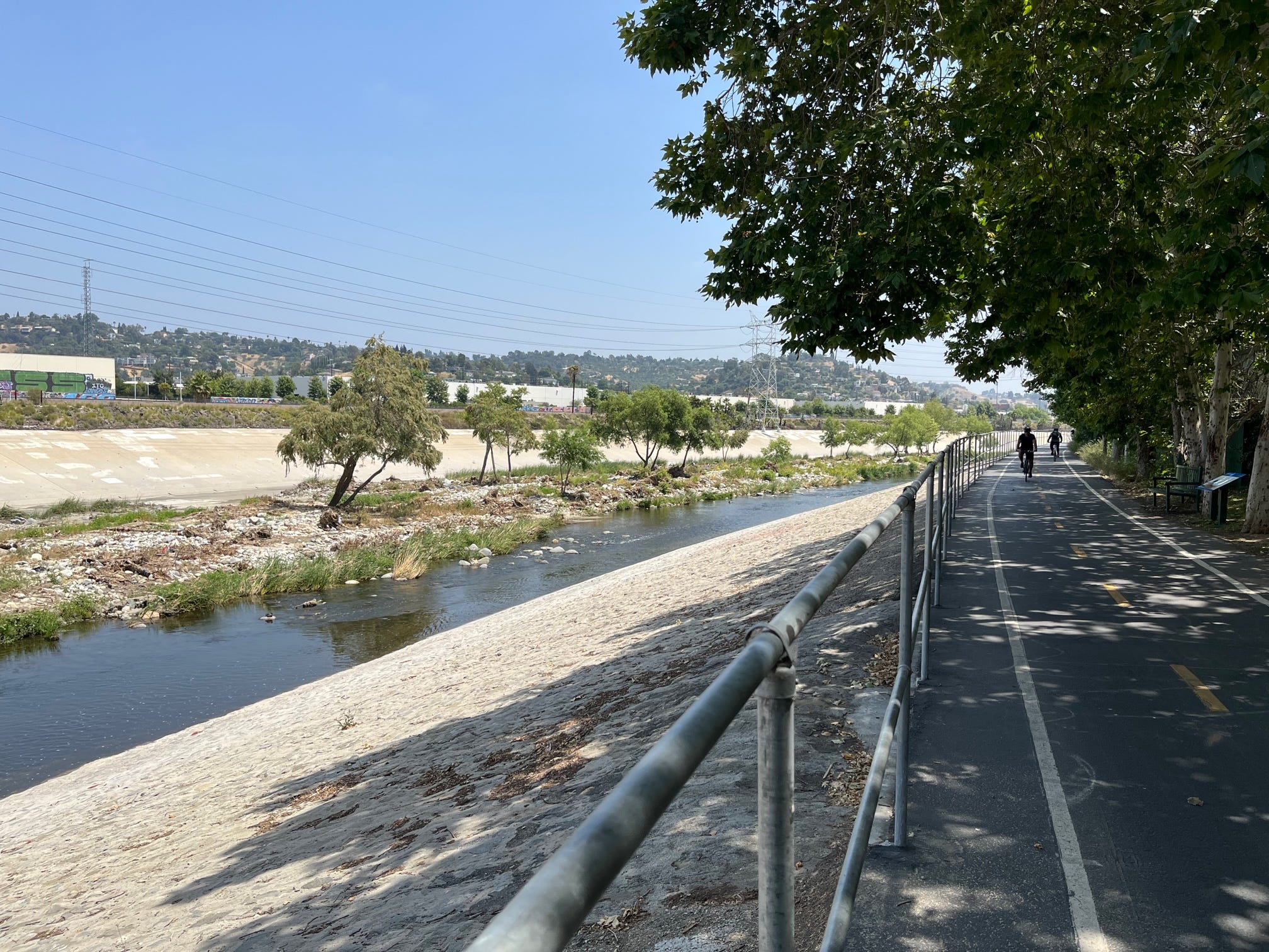
Photo credit: Ron Claiborne
Patt Morrison wrote, "Now that there is wind at the back of reclaiming the river, now that there may be ribbons for politicians to cut with giant scissors and names to be credited on dedicatory plaques, now that everyone wants a piece of the orphaned river, there aren't enough pieces to go around, to satisfy every interest and demand: environmental, natural, recreational, residential, drought-minded."
This past June, the L.A. County Board of Supervisors released its final Master Plan for the river. Eight environmental groups that had been consulted, including FoLAR, rejected it as more of the same -- more concrete flood controls, not enough natural restoration. They asked that their names and logos be removed from the document.* Once again, bureaucrats and environmentalists are at odds over what to do with the river. We've seen this movie before.

Photo credit: Getty Images
*The environmental groups' joint letter in response to the LA River Master Plan can be read at https://boulevardsentinel.com/wp-content/uploads/LARMP-Steering-Committee-Name-Removal-Letter-6.10.22.pdf
Cover photo credit: Peter Bennett