

Will the Great Salt Lake become the Great Salt Puddle?
Will the Great Salt Lake become the Great Salt Puddle?
Persistent drought and water diverted for agriculture use and the area's growing population are threatening Utah's treasure

You can sign up at secondacts.bulletin.com/subscribe to get free posts delivered to your inbox each week and read past articles. You also follow me on Facebook, Instagram and Twitter. Take a chance.
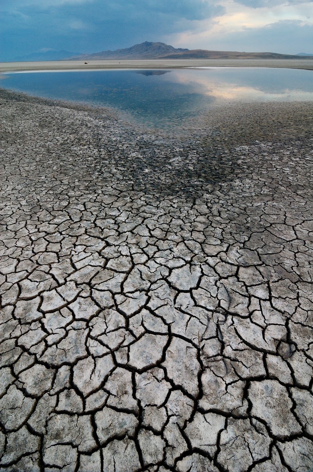
Photo credit: Getty Images
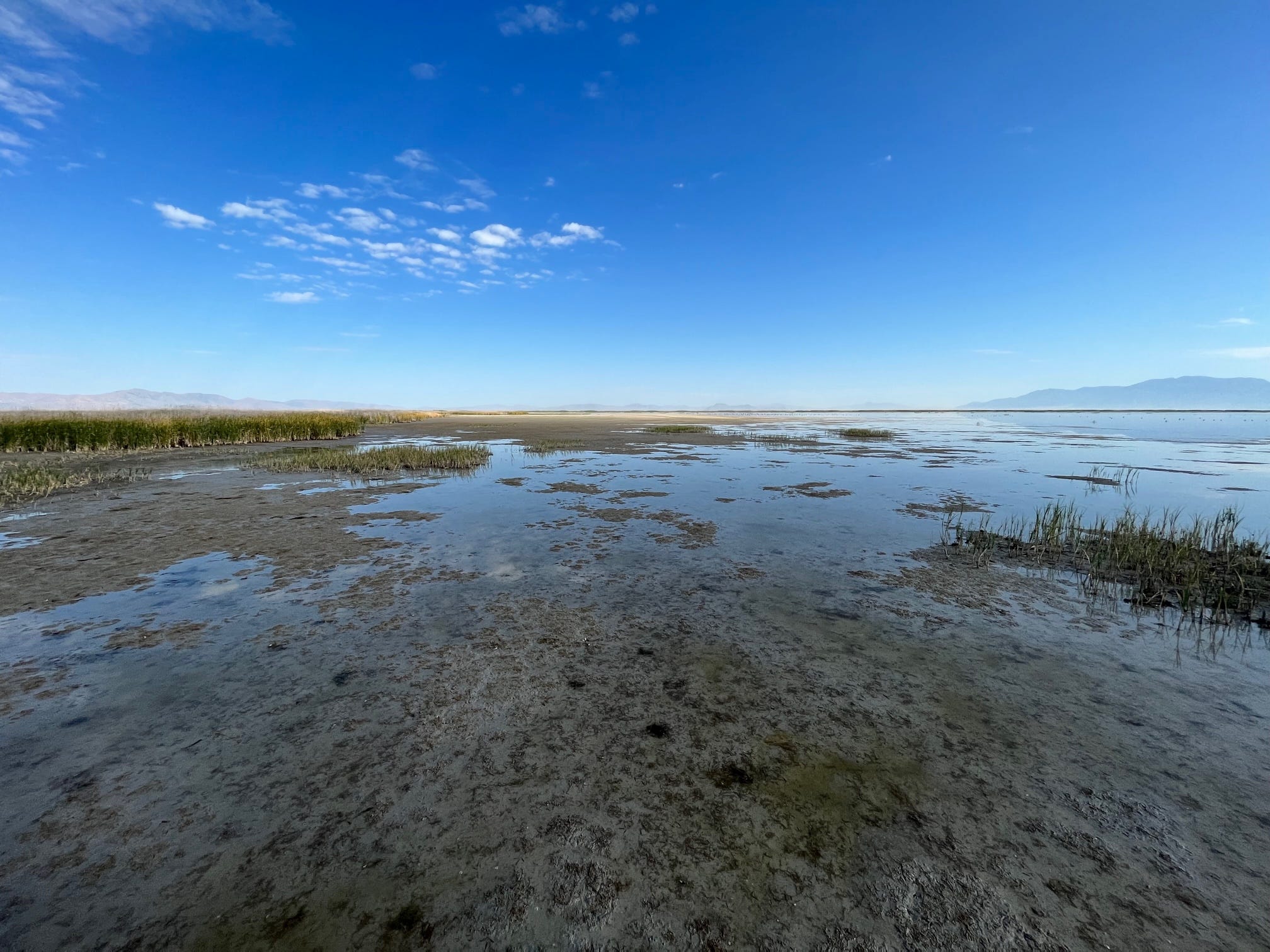
We boarded the airboat from a graveled spit of land protruding from the shore into the Great Salt Lake. With a roar and a blast of air from the huge propeller, we sped west into the lake, skimming over a glistening sheet of water only inches deep.
It was a bright July morning that promised to be hot, maybe 100 degrees or more. Already this summer, the Wasatch Front -- the western side of Utah's 12,000-foot Wasatch mountain range -- has had more blistering heat than normal, or what used to be normal.
As he steered the airboat, R. Jefre Hicks turned to me.
"In three weeks," he said, "this is gonna be dry. This will be mud."
The sound of the approaching airboat caused flocks of birds to squawk and scatter.
Hicks told me that in the fall, the sky is often darkened by millions of migrating birds leaving the lake.
As we traveled, I scanned the horizon. I had no idea the Great Salt Lake was so pretty. Until recently, I had no idea it was in such grave danger.

Photo credit: Ron Claiborne
In 1986, the Wasatch Mountains got buried in snow. When the snow melted that spring, the runoff flowed into the rivers and tributaries that feed the Great Salt Lake. Because it is a so-called terminal basin -- water flows in, but it doesn't flow out -- the lake kept rising, spreading far beyond its normal boundaries. To avert a catastrophic flood, water was pumped into the desert west of the lake.
That year, the surface area of the Great Salt Lake expanded to around 3,200 square miles, from its historic normal of about 1,700 square miles.
Today, the Great Salt Lake surface area encompasses about 800 square miles, roughly half its normal size, and a quarter of what it was that record year of 1986. Last month, the lake hit its lowest level on record -- 18 feet below its historical mean. Left alone, on its current trajectory, it will disappear.
There are basically two reasons the Great Salt Lake is drying up. The first is the prolonged megadrought affecting most of the Western U.S. Some scientists blame climate change. Some say it is a natural meteorological cycle. It may be both. What's not debatable is that it's happening. In Utah, there has been less snowfall in recent years. Less snow, less runoff getting to the lake.
"They've done some core samples of some of the current trees and it's the worst drought in over 1,200 years," State Rep. Joel Ferry, who was recently appointed director of Natural Resources, told me by phone.
"We like to have over two feet (of water) come into the lake every year," said Laura Vernon, the department's Great Salt Lake coordinator. "This past year we had over a foot come into the lake and last year we had less than a foot. Eight of the last 10 years we've been in drought."
The other factor affecting the Great Salt Lake is the diversion of water for agricultural use, and to quench the thirst -- and to water lawns and, yes, wash cars -- of the growing population that resides along the Wasatch Front, which includes Salt Lake City, Provo, Ogden and those cities' suburban sprawl. It is one of the fastest growing regions in the country, its population now roughly 2.5 million. That is expected to increase by 60 percent by 2060, according to the New York Times.
"It's a combination of drought and diversions," Ferry said. "There's a lot of demand on the water resources and it's just being held up and not getting down to the lake."
Last month, the lake hit its lowest level on record -- 18 feet below its historical mean. Ferry attributes about 11 feet of the loss of depth to diversion, about 7 feet from drought. Every foot the lake level declines exposes 1,500 square miles of land, according to Ferry.
"We're going to setting, week after week, record low this year, which is pretty tough, pretty difficult," he said.
Among other things, the Great Salt Lake is an important bird habitat. Each year, tens of millions of birds -- representing more than 250 species -- stop there on their way south. They feast on the lake's tiny brine shrimp and microscopic brine flies, the only organisms that can survive in the highly saline water (Brine shrimp are also used as food by fish farms. It's a $60 million a year an industry.)
"If this keeps going, really another year or two of drought, we could lose our bird populations," says Dr. Wayne Wurtsbaugh, a limnologist (someone who studies inland waterways) and professor emeritus at the University of Utah, where he taught for 40 years.
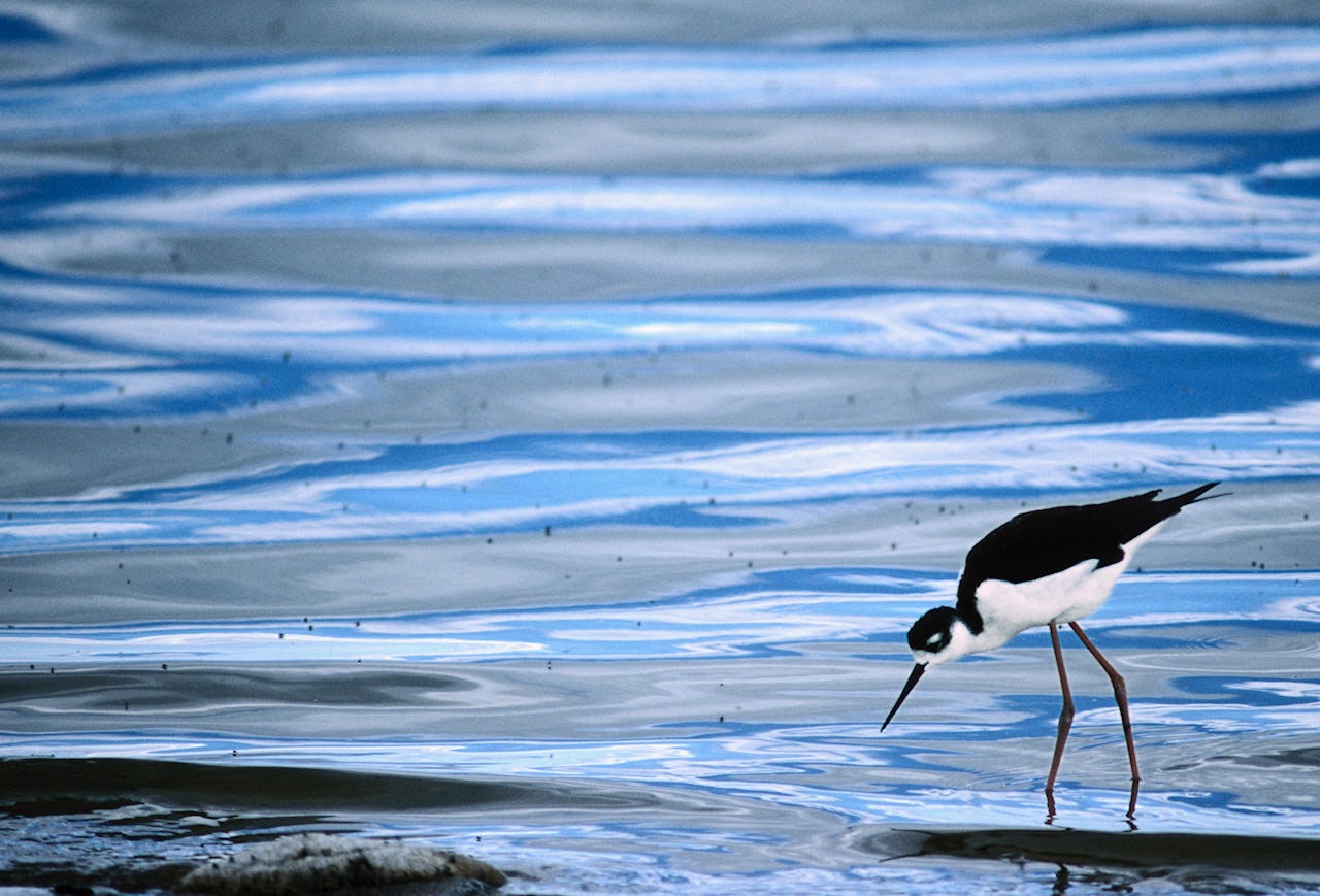
Black-necked stilt feeding on brine flies, photo credit: Getty Images
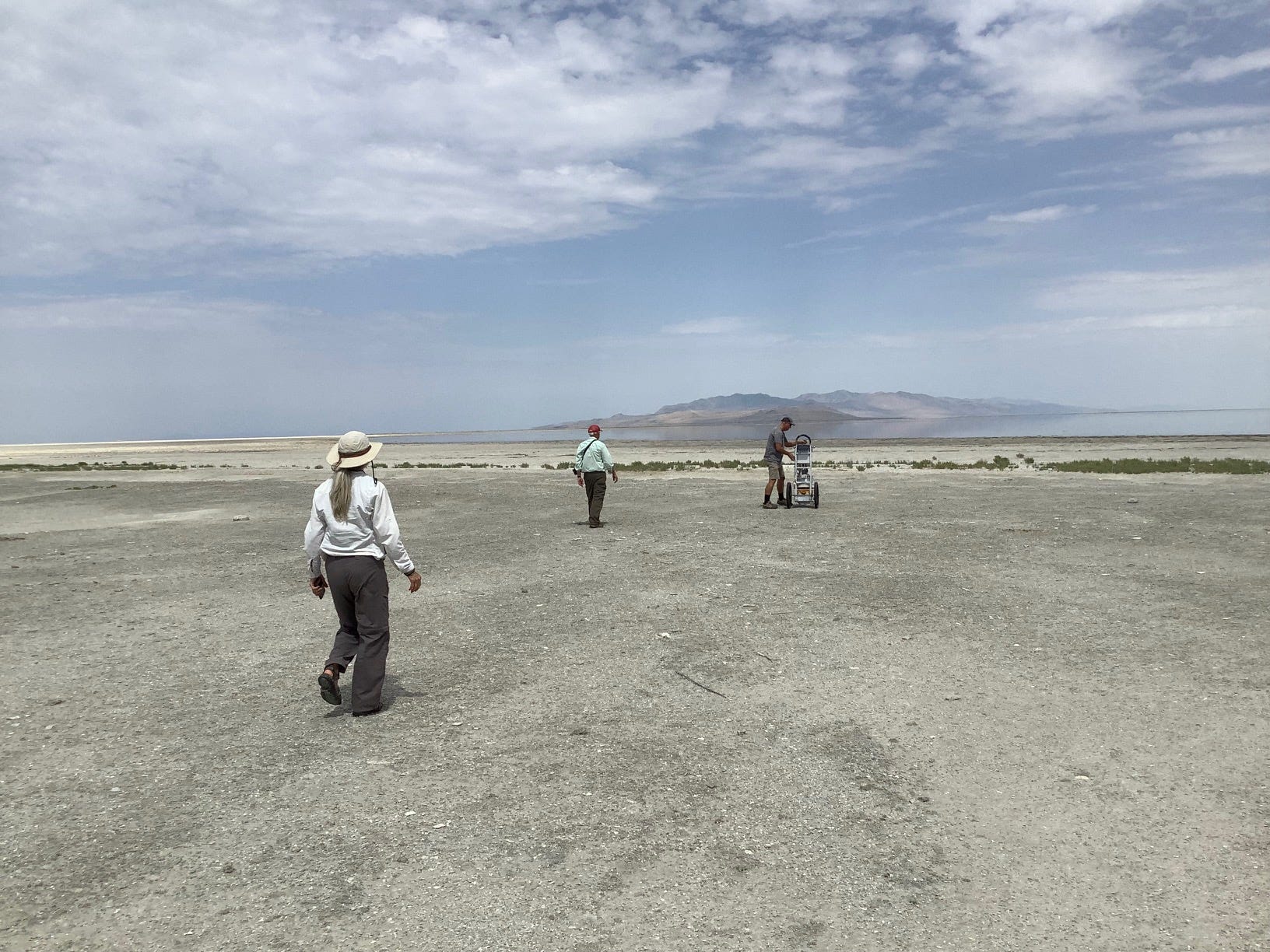
Our airboat tour over, I drove with my hosts -- Lynn DeFreitas, executive director of Friends of the Great Salt Lake, Dr. Kevin Perry, an atmospheric scientists from the University of Utah and Dr. Wurtsbaugh -- to a causeway to Antelope Island at the southern end of the lake.
We crossed the causeway -- there was almost no water on either side of the elevated roadway -- parked and walked to the marina at the north end of the 28,000 acre island, which is a state park and popular recreation area.
The site of the marina was a shock. There were no boats, no water. The slips sat eerily empty on the desiccated surface. The lake had retreated to far in the distance to a half mile away, maybe more. The water in the marina dried about four years ago. The posted warnings about boating safety ("Wear Your Life Jacket!" "Boat Smart From The Start.") seemed a mockery. A larger marina on the southern end of the lake was closed just two weeks earlier, but I was told some of the boats were still there, marooned in the mud.

Antelope Island marina, photo credit: Ron Claiborne
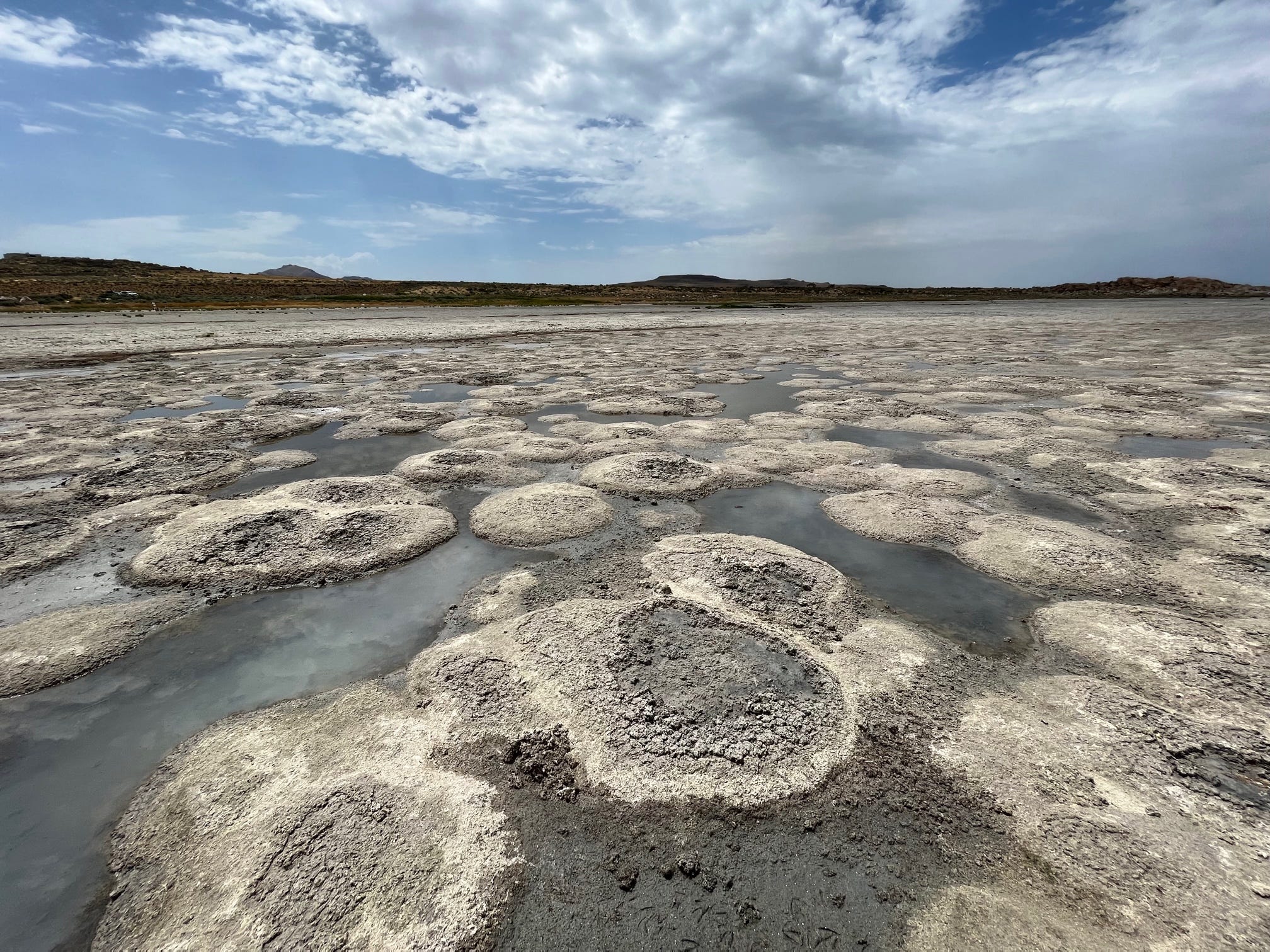
We left the marina and walked over to the beach. There were a few vehicles parked at a campground that was now far from the water. We walked out onto an expanse of about 20 to 30 yards of hard-packed crust. Beyond were what looked like large discs of rocks in the shallow remnants of the receded water.
View from north side of Antelope Island, photo credit: Ron Claiborne
Dr. Perry pulled a heavy, metallic machine that he'd strapped it onto a dolly, dragging it down to the crusty surface. For years, he has been studying the contents of the dust that comes from the newly-exposed lakebed. In high winds, the dust blows into the populated stretch east of the lake. This past spring and early summer, he said, there have been dust storms so severe they've enveloped the area in a thick haze and affected the quality of the air people breathe.
"Some of the particulate matter is small enough to inhaled in your lungs," Perry told me. "It doesn't matter what that dust is actually made of. If the concentrations are high enough, it can impede your lung function and cause respiratory distress. But I also found there are higher concentrations of heavy metals including arsenic that we would prefer not to breathe in the long term."
He said the arsenic, which apparently occurs naturally, has been detected at levels "well above" what the U.S. Environmental Protection Administration recommends for soil.
Dr. Perry (far right) taking dust samples, photo credit: Ron Claiborne
Reading about what is happening to the Great Salt Lake, I came across references to the alarming fates of the Aral Sea in Asia and Owens Lake in California. The analogies are inexact, but still instructive and scary.
The Aral Sea, which straddles the border between present day Kazakhstan and Uzbekistan in central Asia, was once the fourth largest inland lake or waterway in the world. It covered roughly 26,000 square miles in the mostly desert area. Like the Great Salt Lake, it was in rough equilibrium -- roughly the same amount of water came in from river flow, roughly the same amount was lost through evaporation.
In the 1960s, when it was still part of the old Soviet Union, water began to be diverted from two of the main rivers feeding the Aral Sea for agricultural irrigation.
"By the 1980's, during the summer months, the two great rivers virtually dried up before they reached the lake," says an entry in the Encyclopedia Britannica. "The Aral Sea began to quickly shrink because of the evaporation of its now unreplenished water."
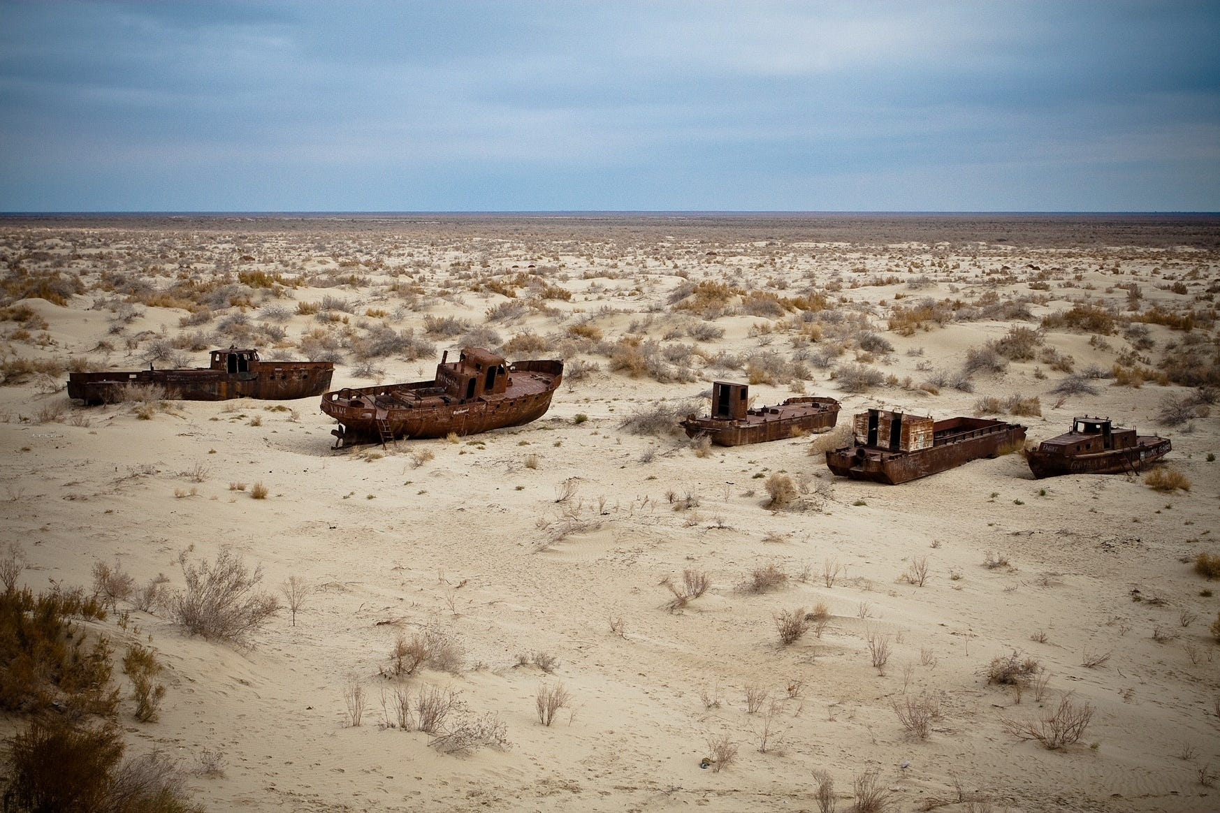
Stranded fishing boats in dried up portion of the Aral Sea, photo credit: Getty Images
As water levels fell by 50 feet, the Aral became two smaller lakes, then three even smaller lakes. The lake continued to recede, falling another 200 feet, exposing the lakebed.
"The salt and mineral content of the lake rose drastically ... making the water unfit for drinking purposes and killing off the once-abundant supplies of (fish)," according to the Encyclopedia Britannica.
"The fishing industry all along the Aral Sea was virtually destroyed. Winds blowing across the exposed seabed produced dust storms that buffeted the region with toxic dust contaminated with salt, fertilizer and pesticides. The area's inhabitants suffered health problems at unusually high rates -- from throat cancers to anemia and kidney diseases -- and infant mortality in the region has been among the highest in the world."
In California, Owens Lake once covered 100 square miles. In the early 20th century, Los Angeles bought the rights to the Owens River, which fed the lake, and diverted the water to the growing city. The lake subsequently dried up.
"For much of the 20th century, it was the worst source of dust pollution in America, according to a 2020 study by the National Academies of Sciences, Engineering and Medicine," the New York Times reported.
Local officials sued L.A. and won. Los Angeles has since spent $2 billion on efforts to contain the wind blown dust. Nothing has worked.
Ground that used to be under water in the Great Salt Lake, photo credit: Ron Claiborne
Lynn DeFreitas of the Friends of Great Salt Lake to me, "I'm an optimist. But I'm not naive. My hope is that we can bring people along and we can elevate a sense of urgency and action and result. Maybe people need maybe people need to feel the sense of urgency in order to respond."
The state of Utah has responded with a flurry of legislative actions aimed at promoting conservation and allowing more snowpack runoff to reach the lake.
Even if those measures are effective, Ferry said, "it's going to take us a number of years to be back out of this."

Photo credit: Ron Claiborne
I asked Dr. Perry, the atmospheric scientist, what the Great Salt Lake means to him.
"I love the solitude," Dr. Perry said. "I love the beauty. I love the wildlife. It's just absolutely amazing that we have this incredible ecosystem on our front door,"
As he spoke, we were looking at Farmington Bay in the southeastern portion of the lake from a vantage point on Antelope Island. The bay was mostly dry.
Cover photo by Ron Claiborne